Sunday, October 3, 2010

Lochgilphead has a Golf Course!


This is within the town, and walking distance from the shopping area.

Really, Lochgilphead is a very attractive town!

Lochgilphead


Lochgilphead's architecture is of the traditional highland variety. This is the street that runs along the lochside. Note that the bus stop is right there, beside the Information Scotland centre. Very handy, that.


The main attraction of Lochgilphead, (for me) was the Argyll and Bute Archives. Its collection is among the best of its kind, and the Council has even provided the public with a small reading room. The archivists are extremely helpful, too. And, right next door, there is the excellent local library! If this sounds like I am gushing, well, I am: anything to encourage the Council to build on this archive. It is most useful for those interested in family history, etc.

Lochgilphead


Lochgilphead is the most populous town in mid Argyll. The photo on the left shows you the lovely park-like atmosphere along that harbour.

There is a mysterious fountain on the other side of that white building. Murdo MacDonald, Argyll's historian, has recorded, in "The Kist 63", Spring 2002, page 13, the foll0wing information:

It commemorates Dr. Alexander Rodger Fraser, ship surgeon, who died 4th Sept 1894, in the Gulf of Suez on board SS Manora. He was the son of the Rev. William Fraser, Minister of the Free Church Congregation in Lochgilphead. Dr. Fraser was a graduate of the U of Glasgow..."


On the south side of the Loch, there is Kilmory Castle, which is now the headquarters of the Argyll Bute council. Around it is a truly lovely garden. Apparently, this was laid out in 1830. Wikipedia has an extensive description of this building.

The Crinan Canal lies on the south edge of Lochgilphead. It connects Ardrishaig on Loch Fyne on the east, to Crinan and Bellanoch on the Jura Sound on the west. Today, it is the path taken by yachts who travel through the West Highlands in summertime. On the other side of the canal lies a very old and historic estate, "Auchindarroch", or "Oakfield".


Keills


Keills lies south of Tayvallich and faces Jura Sound. It is here that the a pier was built in the early 1800s. Cattle from Islay and Jura were conveyed across the Sound to this part of Knapdale. The pier, build with Thomas Telford's guidance, is, like its twin at Lagg on Jura, is gradually disappearing into the water. To refresh your memory, this is the pier on Jura:


This area was once part of the Clan McNeill territories However, by the early 1800s, this part of the clan had either moved to Colonsay, or become bankrupt. Obviously, ownership of this section of Knapdale was a valuable source of income, given the large cattle industry of the 1700s. But after Waterloo, there was a post-war depression that particularly affected the Highland's droving business. In 1831, John MacNeill Esq, "formerly of Oakfield, now of Gigha", gave up Keills, Keilmore and Keilbeg, and the Ferry and privilege of Ferrying, and the Mill built back in the day of Sir James Campbell of Auchinbreck, etc etc to his major creditor, the Renfrewshire Banking Company. By 1837, the latter bank had sold the estate of Neill Malcolm of Poltalloch.

On the other side of a ridge from the Keills farm, there is a very old, historical Keills Chapel, dating from the 8th century. Knapdale People site has along with its cemetery inscriptions, an archaeological description of this building. The very large cross inside the chapel shows St Michael trampling on the dragon, above a nest with three eggs symbolizing the Trinity, and a cleric holding a book. A copy of this cross has been erected outside, up the hill from the chapel.

Carsaig near Tayvallich

Carsaig Bay faces Jura across the Jura Sound. The earliest Free Church congregation built a church at Carsaig. As far as I know, it has been demolished, although the Manse remains, as a private home. I'm very interested in the Free Church in Knapdale, and so was disappointed that the building has disappeared!

However, the cemetery is there. Alison Dawson did a fine job in recording the inscriptions in the old part of this cemetery. There was a puzzle, though: a stone enclosure with no entrance, and no inscription that I could see. However, Ms Dawson found her way inside, and notes that inside this ruin there is a mural:
This is erected over the remains of ARCHIBALD CAMPBELL OF STRONDOUR who died on Novr ye 13th 1719 in the 42nd year of his age, by the direction of DANIEL CAMPBELL OF CARSAIG and ALEXANDER CAMPBELL JUNR Mercht in Glasgow, his sons 1748.
(followed by inscription in Latin)

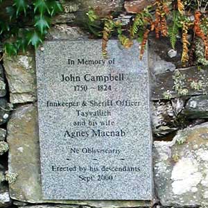
On the outside wall of this ruin, there is a memorial to John Campbell an Innkeeper and Sheriff Officer, with his wife, Agnes McNab. It has been erected in by his descendants in the year 2000. This particular John Campbell appears a multitude of times in my people data base. He was a merchant as well as an innkeeper, and as such did a lot of business with the Inverneill Estate. In 1803, he appears on a list of men eligible to be balloted for membership in the Argyll Militia. Also, he and his wife had a number of children. When you go to the data base, go to the 'advanced search' and enter his name and "Tayvallich".

We were lucky (again), in that the weather was very fine and sunny. This is a photo of the cemetery on our day in Carsaig:


Tayvallich

Tayvallich surrounds a harbour facing east towards Loch Sween. When we were there, a ferry operated from this harbour to Jura.
The village's website is a good one, informative, with a listing of 'things to do' when you are visiting.

In the bad old days, it's geographical setting meant it needed plenty of 'duns' on the surrounding hills. "Tayvallich" is an English form of the Gaelic, "Tigh Bheallich", meaning "House of the Pass". It sits on the east end of a narrow piece of land that almost divides its peninsula in half. On the other side of this neck, less than a mile away, is Carsaig.

Marion Campbell's booklet, Mid Argyll, an Archaeological Guide includes a splendid description of the route from Bellanoch on the Crinan Canal south to Keills. She notes on page 21, that Tayvallich village is covered by 2 forts on the west, and one on the south. They are hard to find, but she said that Dun a'Chogaidh ('Fort of War' or a'Chrocaidh, 'of hanging' ) can be reached by scrambling up from a caravan-site at the north of the bay. I would say that if Marion Campbell found it difficult to find that dun, then it is REALLY difficult!

Monday, September 27, 2010

Inverneill Mausoleum, on Loch Fyne

Major General Sir Archibald Campbell of Inverneill has become one of my favourite Knapdale characters. I have devoted a very large part of KnapdalePeople to this gentleman, and have been able to reproduce copies of family paintings on my site because of the great help from one of his (indirect) descendants, Neill Campbell. During the 19th Century, two proprietors owned most of Knapdale: the Campbells of Inverneill and the Malcolms of Poltalloch, and so to understand Knapdale, it is necessary to understand these Estates.

The Inverneill Campbells exemplified the Highland military aristocracy who - after Culloden - joined the British Empire and in doing so, made their fortune. Unlike the Campbells of Duntroon, the Inverneill family did very well financially, and managed to maintain their Knapdale Estates to the time of World War I.

The memorial inscriptions in the Inverneill Mausoleum are in the Knapdale People site. By reading those inscriptions, you can see the history of the British Empire.

With the help and guidance of Inverneill House's present owner, Gordon Hutton, we managed to track down the Mausoleum. This was a true adventure, and without Mr. Hutton, I would never have scrambled over that last fence (and he never laughed, either, he is a kind and wonderful gentleman!)

The area is really a deciduous jungle. In the photo on the right, you can sort of see me, within all the leaves and trees. There was once a path to the Mausoleum, but this has disappeared. Two large sequoias have grown up outside the mausoleum's outer wall, which helped Mr. Hutton guide us to the building from the road and across a couple of cow pastures and a small forest.

It was a lovely building, carefully planned and built, now well on its way to ruin, and it made me think of Shelley's poem, "Ozymandius."


Over the front entrance, there is the Campbell of Inverneill Coat of Arms; and on the back, there is a stained glass window. The latter has been broken. Plywood covers the hole.


St Columba's Cave on Loch Caolisport


On the south western side of Loch Caolisport, there is a ruined Chapel and behind that, a cave. This is known as "St Columba's Cave"

St Columba (c520 to c600) was an aristocrat who founded Celtic Christianity in, among other places on the Irish Sea, Iona. This particular Cave is on the shore of that sea, and it is not ridiculous to think that, indeed, it was first used by that Saint.


Inside the cave there is still the remains of an altar. The cross scratched onto the wall a very long time ago has been emphasized with white colour in modern times.

Marion Campbell of Kilberry produced a lovely booklet in which (on page 13) there is a description of this site. I have reproduced her "Mid Argyll Archaeological Guide" in pdf form in Knapdale People. Before the Reformation, this Cave and its Chapel would have been a major pilgrims' destination.

Cladh a Bhile on Loch Caolisport

We could not find this ancient burial ground. It is the one failure I most regret. Sorry.

Ormsary Estate on Loch Caolisport


Because a branch of my ancestors left Ormsary Estate for Canada (in 1853), I have a special interest in this place on the east side of Loch Caolisport. If you check the 1694 "Hearth Tax Records" on my site (page 6) you will see that there are a number of McNeills living along that Loch.

Donald McNeill is noted as living at Drumnamuckloch in Kilberry Estate in 1694. In 1672, this gentleman had acquired Crear Estate by Charter from the 9th Earl of Argyll. Crear is south of Ormsary, on the coast, with (one presumes) access via the adjacent Crear Burn to the uplands behind Ormsary. On our visit to Ormsary, Lord Lithgow very kindly drove us up into that area. To me, it looked grim, especially as compared to the lush green along the coast. And the McNeills were known as a primarily sea faring clan.

Looking on the bright side, there is, a loch up there, Loch Nan Torran. And the Landranger map shows that the place is actually laced with burns. Former habitations were probably in those green areas you can see in the photo. At the time, the clansmen made their homes out of turf, not stone.

During Argyll's failed rebellion against James II of England in 1685, this Donald McNeill supported Argyll. Perhaps this is why we see him living in a one-hearth home in 1695
.

Donald McNeill was the son of Neill McNeill of Arichonan. His eldest son, Malcolm, is also known as being "of Arichonan". It would seem that Donald spent the last years of his life working to move his clansmen from the Crear uplands. With the triumphant return of the Campbells of Argyll, he exchanged Crear for Colonsay Island. It was, however, his son Malcolm (of Arichonan) who actually led the McNeill Clansmen to Colonsay and Oronsay.


Sunday, September 26, 2010

Arichonan


Like Leac Na Baan, Arichonan was built at the top of a hill, presumably because you could see any approaching ship coming up the Loch. The buildings are now in ruins and empty of people. A study of Arichonan has been one of my own major projects, and you can see the results of all that here, in KnapdalePeople.

When I visited Arichonan in 2002, there was a large plaque on site recounting the story of the Clearance that occurred here in 1848. This time, in 2010, there was no sign, except one warning against falling stones (!). Further, there is no longer any sign on the road indicating that up that hill there is a ruined township. We found the trail, though. It is still obvious and mowed. On the other hand, there is a modern house farther down the road to the south, with a sign identifying it as "Arichonan Farm". Since my 2010 visit, I have wondered if we are now meant to use that path up to the ruins?


Castle Sween


This is an impressive castle which dominates the sea approaches to Loch Sween. It was known as the "Key to Knapdale", and at Knapdale People, there is a whole section devoted to this fort. It was destroyed when the MacDonalds invaded Argyll in the 1640's, and never rebuilt. As you can see in the above photo, directly across Loch Sween is Taynish. Castle Sween is now a major centre for tourism. A flourishing trailer court lies next to it, and when we visited, there was lots of little boats in the water.

Road to Castle Sween


On the way to Castle Sween, south from Leac Na Baan, there was a gate with a pair of coats of arms. They interested me because they were so fresh and new, and the portcullis reminds me of the one for the city of Westminster in England.


Thursday, September 23, 2010

Standing Stones, Myths and Rituals

Whenever you see some ancient pot described as a 'ritual' pot, you know that really, the archaeologist has no idea what it was actually FOR. So, 'ritual' is a handy hold-all for all the strange items of we dig up and wonder at, like, for example, the stone circles at Arran's Machrie Moor and the multitude of circles and henges and giant stones scattered over Kilmartin Glen. It's darned 'mythic' for sure....

Anyway, what should one think, when a married couple, living in northern Alberta, descended (a long way back) from West Highland people, build this stone circle in their yard just because they like rocks, big rocks, Standing Stone rocks, maybe of a 'mythic' kind:

This is Shane, delivering a birthday present to Sara:


And here is one of the more spectacular rocks, put up this August:

Wednesday, September 22, 2010

Leacnabaan (White Rock)


Leac Na Baan, now a Bed and Breakfast, was in the past a farm/township, part of the Arichonan Estate. In 1798 and 1802, when Niel Malcolm of Poltalloch purchased the area, he inventoried the houses and other shelters now part of his holdings. At KnapdalePeople, on page 10, there is a carpenter's description of the houses in 1802. There were a number of people over several generations who made Leac Na Baan their home. If you go to the "People List" at Knapdale People, and then to "Advanced Search", enter "Leac Na Baan" in "Place" and enable some 500 entries, you will find quite lots of names, mostly Births and Marriages, but also people eligible for the Argyll Militia, etc.


Lying near the cup shaped depression is the remnant of a very impressive standing stone.

Dunadd, and Cup Shaped Depressions


First, a closeup of Dunadd's "cup":

South of Kilmartin Valley, and of the Crinan Canal there is a township (now a B&B, White Rock Bed and Breakfast), known by the Gaelic name "Leacnabaan". Mr Hamilton, the proprietor, is an enthusiastic historian (as is his wife), and he has noticed several things about this place. When he looks north through a notch in the hills, Dunadd is clearly in sight. In fact, he believes that a small rise next to his home would have been ideal for placing signal fires (ie, like in the Lord of the Rings movie).


And then, close to a fallen standing stone at Leacnabaan, there is ANOTHER cup shaped depression:


Finally, there is a very similar cup shape inside St Columba's Cave on Loch Caolisport!

Interesting, No?? If anyone has archaeological/historical notes relating to these 'cups', let me know.

Dunadd Fort (Kilmartin Valley)


Dunadd is a rocky outcrop a few miles north of Lochgilphead. There is little left of its past now. But back in the day, when the Scottish tribes came from Ireland and settled in the West Highlands (about 500AD), they fortified it ("Dun" means "fort"), and made it the capital of their country, which they called "Dal Riata."

This hill sits in the middle of a very large bog, Mòine Mhòr (Great Moss) now largely drained through the efforts of the Malcolms of Poltalloch, but through most of time, an excellent part of Dunadd's defensive system. From its height, you can look down on the Kilmartin Valley and the River Add... quite a lovely scene!


There is every reason to believe that men were anointed as kings on Dunadd's summit. You can still see a large, worn, stone which features a foot-shaped depression, as well a cup-shaped depression. At one time, the stone also displayed a carving of a boar (very kingly beast), and I suppose with a lot of imagination, its shadow still remains. I am sure I saw the drawing a few years ago on a previous visit, but time goes by and events happen, I guess.

The Vikings, on their longships, arrived on Britain's horizon in 791, and changed everything in the Western Highlands. Dunadd was no longer tenable as a capital. By 850 AD, around the time of King Kenneth McAlpine, the Scottish leaders had moved their headquarters east, away from the coast, to Scone, near Perth.


Monday, September 20, 2010

Kilmartin Glen and Carnasserie Castle


Carnasserie Castle sits on a hill a couple of kilometers north of Kilmartin Village. It was built for the 5th Earl of Argyll about 1565, by the then Bishop of the Isles, John Carswell. This Earl was one of the foremost leaders of the Protestant Reformation; and John Carswell (an excellent Gaelic scholar) is famous for translating John Knox's prayer book into Gaelic, so that it could be read by the people of the West Highlands.

Above the main door, there is an oblong panel with a carving of a shield commemorating one of the (probably) most rancorous marriages of that century: the 5th Earl of Argyll, Archibald Campbell, and Jean Stewart (a half sister of Mary Queen of Scots.) On the left, there is the Campbell galley and the 'gyronny' of eight; on the right, a lion rampant for the royal arms of Scotland. Along the bottom, in Gaelic script, there is carved, "Dia Le Ua N Dubh(n)e" (God be with the O Duibhne). The Campbells were, in Gaelic terms, the "O'Duibhne". The couple managed to divorce in 1573, the year of Archibald's death.


During the terrible wars of the 1600s, Sir Duncan Campbell of Auchenbreck garrisoned the castle as a supporter of the 9th Earl of Argyll's uprising against James II (Stewart) of England. The MacLeans of Torloisk, etc. successfully besieged the castle, blew part of it up, and murdered Auchenbreck's uncle. Good times.

Kilmartin Gala and the Mid Argyll Bagpipe Band


Luck was with us in Kilmartin, because we happened upon a Gala put on by the local people. There was a lot going on, of course, including a peregrine falcon...

And then there was the Mid Argyll Bag Pipe Band! This was a real treat as they put on a particularly energetic show. The Drummer girls were incredible. And the music was so well done. This band has been in existence in Mid Argyll (and Lochgilphead) for most of the 20th century and given the relatively small population of the area, is very conscious of the necessity to encourage young people to take part. This is absolutely evident in this video, which I totally recommend (it combines hip hop dancing with piping!!). Anyway, I purchased the CD and here is the cover:

Kilmartin Church and the Campbells of Duntroon

Inside the Church there are a number of plaques on the walls, some remembering the Malcolms of Poltalloch who purchased Duntroon Castle in the late 1700s, and a couple remembering the previous Campbell Lairds. This one is particularly interesting, I think, evocative of the Scottish aristocracy of the 1700s, and their attempts to make their fortune within the British Empire: